







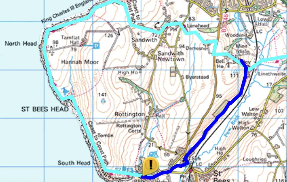
A 3km section of the King Charles lll England Coast Path and the Coast to Coast Path is closed due to land slips between St Bees (NX959118) and Fleswick bay (NX942136).
The temporary route is shown in dark blue on the map below.
Tilhill Forestry has advised the Society of timber operations taking place at Black How Forest, Cleator Moor over the next three to four weeks.
A plan showing the affected area can be downloaded here. We’re advised the work is thinning only but will take place alongside the main forest road within Black How which leads up to Dent Fell. Tilhill Forestry can accommodate the ‘permissive’ access using operator and machinery as banksman when working in the vicinity of the forest road. Alternatively, they may divert the C2C along the ‘unauthorised’ path to the south of the works area. There will be timber haulage and roadside timber stacking.
Tilhill Forestry ask walkers to pay attention to any on-site signs and to follow any instructions.
The Lake District National Park Authority made an order on 11th August 2022 to prohibit all public traffic for all purposes from proceeding over part of bridleway 407021 at Gillerthwaite, Ennerdale Forest to enable the felling and extraction of timber.
The order will take effect on 26 August 2022 and will continue in force for six months but the work is expected to take only two months, as and when the signs are displayed. When works are taking place, signs will be erected showing the closed path and the alternative route(s). The path will be accessible as normal other than on these days. If the works have not been completed the order may be extended for a further period with the Secretary of State’s approval.
A map showing the bridleway affected and the alternative route(s) can be downloaded here
Tilhill Forestry has advised the Society that it is once again harvesting timber at Black How Forest, Cleator Moor.
A plan showing the affected area, and the permissive Coast to Coast (C2C) route, can be downloaded here. The C2C path will not be closed or re-directed but Tilhill Forestry do ask walkers to pay attention to any on-site signs or instructions and to be aware of timber lorries along the forest road.
The Secretary of State has granted an extension of the Order made by the Lake District National Park Authority which closed a number of paths in Ennerdale Forest temporarily to enable forestry operations – felling, thinning, clearance and extraction – to take place. The new Order authorises the extension of the footpath closures until 02 August 2021, or until the completion of the works, whichever is the earlier.
These temporary closures affect walkers on the Coast-to-Coast Walk. Not all paths will be closed at any one time and some may be only closed for short periods.
Alternative routes will be available when certain paths are closed. We’re advised that there will always be one east-west route open, as well as at least two routes onto the fells to the south. Local signage will explain what is closed/available at any specific time.
For your own safety please follow Forestry England’s signed diversions at all times.
A map showing the paths affected, and the alternative routes, can be downloaded here (PDF).
If you have any queries, please contact Nick Thorne, Countryside Access Officer, at the LDNPA – email nick.thorne@lakedistrict.gov.uk
While this temporary footpath closure doesn’t affect the official Coast to Coast route walkers may wish to be aware that the Lake District National Park Authority has made an order to close a footpath south of Crag Farm, Ennerdale Forest near to the official route. The closure is expected to be in force for a maximum period of six months from 20th February, 2020 to allow the felling and removal of timber to take place.
A map showing the footpath to be closed and the alternative route can be downloaded here (PDF).
Earlier in 2019 a section of Wainwright’s Coast to Coast Walk near Cleator Moor was closed while Tilhill Forestry were carrying out tree felling operations. Tilhill Forestry advise that the forestry works have been completed and the permissive path which forms part of the C2C route is now open again.
There is still some timber at the roadside. Walkers should please follow any safety guidance from Tilhill Forestry at times when timber is being loaded on to transporters to be taken away.
In response to a request from the Mountain Rescue Association, the Society has been asked to report that a number of Coast to Coast walkers are making serious navigational errors just beyond Black Sail Youth Hostel, and so fail to turn up at Loft Beck for the correct route. Mountain Rescue Teams have been called out on numerous occasions to respond to walkers getting into difficulty on this leg between Ennerdale Bridge and Rosthwaite. The following map serves to reiterate the correct routeing beyond the Black Sail Hut and walkers are advised to pay extra attention to this point of the walk.
To download a printable PDF of this map Click Here